Birmingham City Council
Tree preservation zone
There is a problem
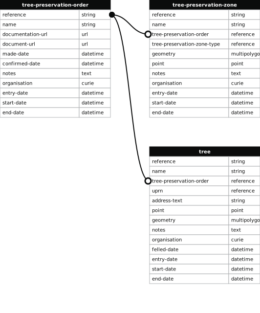
- 1000 entries with tree-preservation-order field must match the reference field in the tree preservation order dataset
THE BIRMINGHAM (LAND AT 539-561 CHESTER ROAD AND LAND AT FIRSHOLM CLOSE, BOLDMERE) TPO 1999
- reference
- 804
- name
- THE BIRMINGHAM (LAND AT 539-561 CHESTER ROAD AND LAND AT FIRSHOLM CLOSE, BOLDMERE) TPO 1999
- tree-preservation-order
- TPO 804
- tree-preservation-zone-type
- area
- geometry
- MULTIPOLYGON (((-1.838604 52.537994,-1.838335 52.538180,-1.837824 52.538528,-1.837823 52.538538,-1.837775 52.538568,-1.837869 52.538642,-1.837875 52.538639,-1.837880 52.538657,-1.837917 52.538686,-1.837977 52.538656,-1.837995 52.538662,-1.838074 52.538724,-1.838101 52.538712,-1.838238 52.538824,-1.838303 52.538880,-1.838337 52.538897,-1.838497 52.539057,-1.838692 52.539194,-1.838760 52.539140,-1.838913 52.539032,-1.838960 52.539001,-1.838965 52.539003,-1.839085 52.538926,-1.839253 52.538782,-1.839243 52.538774,-1.839444 52.538625,-1.839590 52.538511,-1.839560 52.538494,-1.839580 52.538481,-1.839367 52.538364,-1.839344 52.538357,-1.839325 52.538354,-1.839117 52.538230,-1.839112 52.538225,-1.838650 52.537984,-1.838623 52.537976,-1.838603 52.537979,-1.838597 52.537981,-1.838590 52.537986,-1.838604 52.537994)))
- point
- POINT (-1.838696 52.538562)
- notes
- The shaded area represents those properties which fall within the outline of a Tree Preservation Order. To precisely identify trees protected by the Order, you can request a copy of the tree preservation order at the following link.
- entry-date
- 2026-10-15
- start-date
- end-date
How to fix this issue
Your data is missing a tree-preservation-order.
The tree preservation zone guidance explains how to fix the issue:
tree-preservation-order
The reference for the tree preservation order that covers this zone.
How to improve Birmingham City Council’s data
- Fix the errors indicated
- Use the check service to make sure the data meets the standard
- Publish the updated data on the endpoint URL